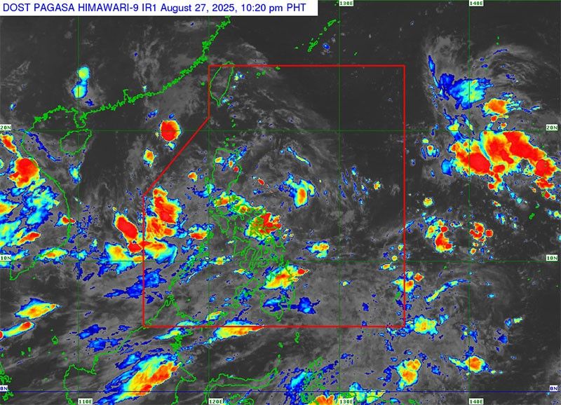
The Philippine Atmospheric, Geophysical and Astronomical Services Administration (PAGASA) has issued an alert regarding a low-pressure area (LPA) located within the Philippine area of responsibility, which is predicted to develop into a tropical depression within the next 24 hours. As of 2 p.m. of August 27, 2025 (PHT), the LPA was situated 305 kilometers west of Dagupan City in Pangasinan, contributing to widespread rainfall across the country in tandem with the southwest monsoon.
The meteorological effects of the LPA are being felt across various regions, with Metro Manila, the Ilocos Region, Cagayan Valley, the Cordillera Administrative Region, Central Luzon, and Calabarzon experiencing overcast skies accompanied by scattered rain showers and thunderstorms. Additional regions including the Visayas, Mimaropa, Bicol, Zamboanga Peninsula, Northern Mindanao, and Caraga are also contending with similar weather conditions due to the southwest monsoon’s influence. In contrast, the remainder of Mindanao is predicted to have generally fair weather, interspersed with occasional rain showers or thunderstorms.
Meteorological forecasts indicate that the western parts of Southern Luzon will experience moderate to strong westerly to southwesterly winds, resulting in coastal waters being classified as moderate to rough, with wave heights ranging from 1.5 to 2.8 meters. In contrast, extreme Northern Luzon will receive moderate easterly winds, whereas the broader areas of Luzon, the Visayas, and Mindanao will encounter lighter winds and calmer seas.
This weather system has already impacted approximately 12,790 families, equating to around 49,379 individuals, who have been affected by the persistent rain and flooding over the past three days. Authorities are closely monitoring the situation to provide timely updates and advisories to ensure public safety and preparedness.

